Assaults on Mt. Mitchell and Marion
Monday May 20, 2024
The Assaults for 2024 are on Monday May 20.
The Assaults communications are provided by SPARC.
The club needs your participation for this event. Not only does it provide support for over 1,000 bicycle riders, it also gives SPARC an opportunity to practice its radio skills in a live scenario. This year we have approximately 9 rest stops (2 operators at each), Net Control (2 or 3 radio operators), Mountain Top (2 radio operators, 1 radio operator for bike truck manifest, and 1 radio operator baggage handler), 1 radio operator end sweep, 1 radio operator motorcycle, 1 radio operator lead vehicle/SAG, at least 10 radio operator SAG vehicles (preferably self-contained), and at least 2 radio operators at the Spartanburg Memorial Auditorium. This adds up to roughly 40 volunteers with Ham Licenses.
This fun event only requires a day or less of your time and most everyone in the club can spare that. By signing up now it gives us a chance to fill up the slots and have reserves for last minute cancellations. If a medical issue, death, or work conflict arises, by all means, that takes precedence and you are excused. I CAN’T EXPRESS HOW IMPORTANT THIS EVENT IS TO THE CLUB AND THE FREEWHEELERS OF SPARTANBURG.
A DESCRIPTION OF THE POSITIONS FOLLOWS:
REST STOPS - The RS operator's job is to let Net Control know when the cyclists arrive at their location as well as any issues that need to be addressed by Net Control or the THE ASSAULTS Directors. This includes any accidents, riders needing to be picked up, supplies needed, or anything else. The RS operator should have phone numbers for the medical personnel in their area. That will be provided to you later. On some occasions, a rest stop operator may be asked to ferry leftover supplies up the course.
SAG Vehicles - These ideally need to be self-contained, radio-equipped and driven by the radio operator. However, we will try to find any interested operator a vehicle to RIDE with. A SAG or Support Vehicle is used to provide support on the road or pick up riders who decide to quit for whatever reason. The radio operator calls Net Control when he or she picks up a rider and relays the rider number and name. If that rider needs their bag delivered from the Mountain Top, that info is given as well. SAG vehicles relay riders up the course from rest stop to rest stop.
SWEEPS - A sweep is a vehicle that stays behind the last rider and reports to Net Control. This is done for the safety of the participants and to give the Assaults Directors an insight of time for the event.
LEAD SAG - This vehicle stays in front of the lead riders and relays info to the necessary parties.
MOTOCYCLES - This job is to infiltrate the riders and help if needed.
AUDITORIUM - This person keeps in touch with Net Control on the arrival of trucks and buses.
RADIO BACKUP - Monitors the frequency and helps out if needed in case of radio failure or whatever may happen.
Any radio operator that uses his or her vehicle for a SAG or is called upon to make a delivery for the ride falls under the operations of the Freewheelers of Spartanburg and those individuals will be told the location of the gas station to fill up at Marion. The SAG drivers names will be on a list at the station. Corrections or additions will be made as needed that day.
All other event positions are NOT covered by the fuel agreement of the Freewheelers.
This is a brief description of what is needed to make this event a success. We do a great job and The Assaults Directors reflect this feeling as well. Give this event serious consideration and the good thing is it’s a FUN DAY.
Thanks in advance. If interested, contact Mike Bonner at mikebonner209@gmail.com
2024 Positions Needed
| RS 1 - | Larry Abelkop NN4SS and Susan |
| RS 2 - | Dave Herschberger KN8Y |
| Dave Collins KG4NHF | |
| RS 3 - | Sharon Moore KO4VPJ |
| Bruce Eash KO4GEQ | |
| MARION - | NET CONTROL |
| Rick Hughes K4BYT | |
| Larry Stevens KD8PYN | |
| Bob Richardson W4RR | |
| RS 5 - | Mike Henley KK4CUT |
| Chuck McCoy N6WOX | |
| Clint Mills KK4BGR | |
| RS 6 - | Brandon Bailey KI4MRX |
| 2 - | |
| RS 7 - | Jim Fagan KI4MJK and Janie |
| Randall Phillips N4JRP | |
| RS 8 - | Bobby Scott KM4TLA |
| 2 - | |
|
MITCHELL RESTAURANT - |
Cline Gore WD4RCS |
| 2 - | |
| MOUNTAIN TOP - | Bret Phillips N9LPT |
| Keith Lewis K4XP | |
| Don Wykel KN4KAS | |
| MOTO 1 - | Duane Ridenour K2HME |
| MOTO 2 - | Paul Sweeney KB4QCE |
| SAG 1 - | Les MacBay W4LSO |
| SAG 2 - | Pokey Burnett KK4UCE |
| Kimberli Burnett KK4UKP | |
| SAG 3 - | Bo Moss KE4HZG |
| SAG 4 - | Steve Jackson K4SLJ |
| Brad Faulkenberry KD4FOS | |
| SAG 5 - | Shane Bishop KN4NNW |
| Randy Bishop KO4NNN | |
| SAG 6 - | |
| SWEEP 1 - | Gary Foster K8HID |
| SWEEP 2 - | Wayne Davis K4SPA |
| Lisa Davis N4BOO | |
| AUDITORIUM - | Art Patterson KE4EAN |
| Karen Marmet KF4BLF | |
| UTILITY - | Mike Bonner K4BON (Big Bird) |
Reminder - All SAGS need to be able to carry bikes and riders. If you would like to SAG or fill a slot, contact Mike Bonner at mikebonner209@gmail.com
2023 Positions & Personnel
| RS 1 - | Larry Abelkop NN4SS and Susan |
| RS 2 - | Dave Herschberger KN8Y |
| Dave Collins KG4NHF | |
| RS 3 - | Sharon Moore KO4VPJ |
| Bruce Eash KO4GEQ | |
| MARION - | NET CONTROL |
| Rick Hughes K4BYT | |
| Larry Stevens KD8PYN | |
| RS 5 - | Mike Henley KK4CUT |
| Chuck McCoy N6WOX | |
| Clint Mills KK4BGR | |
| RS 6 - | Brandon Bailey KI4MRX |
| 2 - | |
| RS 7 - | Jim Fagan KI4MJK and Janie |
| Randall Phillips N4JRP | |
| RS 8 - | Bobby Scott KM4TLA |
| 2 - | |
|
MITCHELL RESTAURANT - |
Cline Gore WD4RCS |
| 2 - | |
| MOUNTAIN TOP - | Bret Phillips N9LPT |
| Keith Lewis K4XP | |
| Don Wykel KN4KAS | |
| MOTO 1 - | Duane Ridenour K2HME |
| MOTO 2 - | Paul Sweeney KB4QCE |
| SAG 1 - | Les MacBay W4LSO |
| SAG 2 - | Pokey Burnett KK4UCE |
| Kimberli Burnett KK4UKP | |
| SAG 3 - | Bo Moss KE4HZG |
| SAG 4 - | Steve Jackson K4SLJ |
| Brad Faulkenberry KD4FOS | |
| SAG 5 - | Shane Bishop KN4NNW |
| Randy Bishop KO4NNN | |
| SAG 6 - | |
| SWEEP 1 - | Gary Foster K8HID |
| SWEEP 2 - | Wayne Davis K4SPA |
| Lisa Davis N4BOO | |
| AUDITORIUM - | Art Patterson KE4EAN |
| Karen Marmet KF4BLF | |
| UTILITY - | Mike Bonner K4BON (Big Bird) |
2024 Radio Support Rest Stop Arrival Schedule
THESE REQUESTS ARE SO NET CONTROL AND THE ASSAULTS DIRECTORS KNOW EVERYONE IS UP AND READY AND IS ON LOCATION OR ENROUTE. THIS ALSO HELPS IN IDENTIFYING WHICH STOPS HAVE VOLUNTEERS ON SITE AND WHEN THEY ARRIVE. ON-SITE REPORTING TIMES ARE AS FOLLOWS:
| REST STOP 1 - | 6:45 A.M. |
| REST STOP 2 - | 8:00 A.M. |
| REST STOP 3 - | 8:45 A.M. |
| NET CONTROL - | ON AIR AT 6:30 A.M. |
| REST STOP 5 - | 9:30 A.M. |
| REST STOP 6 - | 9:45 A.M. |
| REST STOP 7 - | 10:15 A.M. |
| REST STOP 8 - | 10:45 A.M. |
|
MITCHELL RESTAURANT - |
11:00 A.M. |
| MOUNTAIN TOP - | 8:00 A.M. |
| MOUNTAIN TOP TRUCK AND BAGS PERSONNEL - BE THERE BY 10:30 A.M. |
| LEAD VEHICLE - | 6:00 A.M. |
| MOTO - | 6:00 A.M. |
| SAGS - | 6:45 A.M. FROM START TO FINISH |
| 1st SWEEP/SAG - | 7:00 A.M. FROM START TO FINISH |
| 2nd SWEEP/SAG - | 9:00 A.M. FROM MARION TO RS 3 THEN ON TILL FINISH |
| AUDITORIUM - | BE THERE BY NOON OR 1 P.M. |
Les (lead) WILL DROP RIDERS AT MARION AND RUN SAG REVERSE as he chooses or as directed by net control.
Bo and Pokey can start up the route and go reverse and then rotate up the course to finish as per their discretion or as directed by net control.
Sweep vehicle’s main job is to stay behind and report the last riders and pickup as needed.
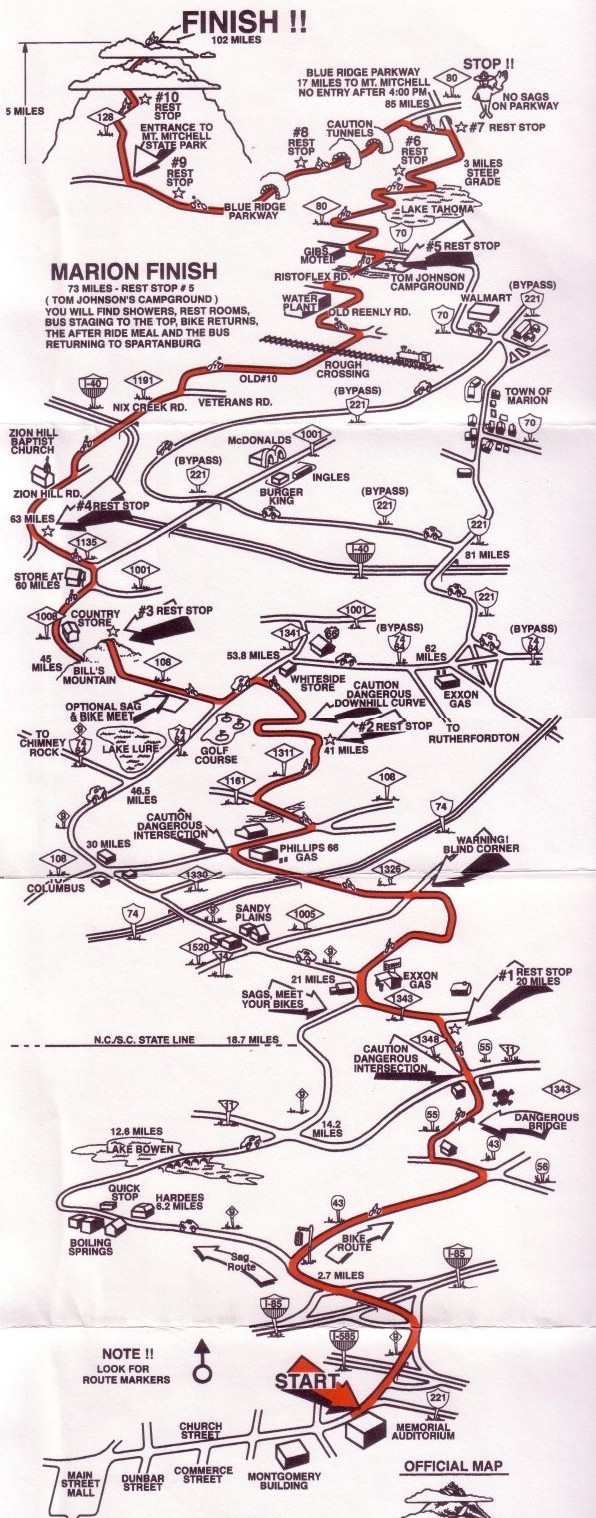
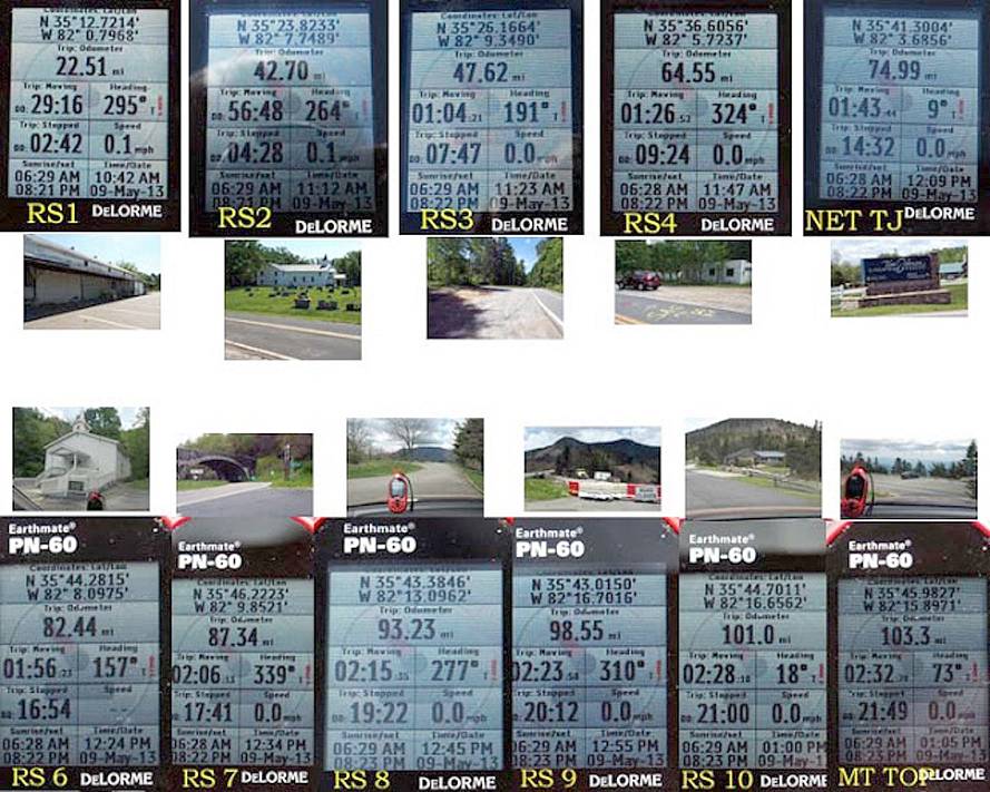
GPS Coordinates
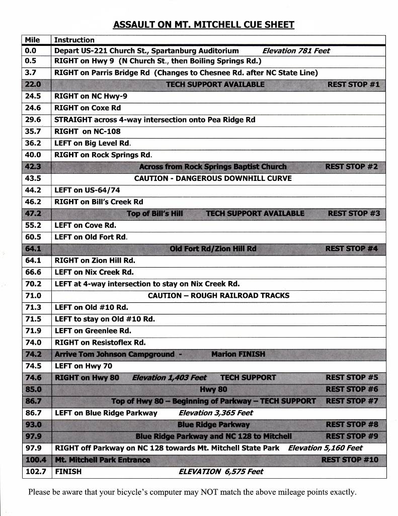
New Direction Cue Sheet

Old Direction Cue Sheet (for comparison)
SPARC Comm. Assignments - Main Freq. is Mt. Mitchell Repeater - 145.190
Emergency Phone Numbers
|
AREA |
Phone Number |
NOTES |
| Spartanburg Co. | 911 | Use up to SC / NC Line |
| Spartanburg Co. | 864-596-2222 | Use up to SC / NC Line |
| Polk Co. EOC | 828-894-3001 | Cell Phone use OK |
| Rutherford Co. Sheriff | 828-287-6247 | North Carolina |
| Rutherford Co. Comm Center | 828-287-6050 | North Carolina |
| McDowell Co. | 828-659-2241 828-659-2197 | North Carolina |
|
|
|
This page updated 3/6/2024